Landslide Technology
  • Home
  • Specialty Services
    • Geotech. Asset Mgmt. >
      • Montana Rock Slope Asset Mgmt. Program (RAMP)
      • Alaska Geotech Asset Mgmt
      • Ohio Landslide Inventory
    • Rope Access
    • 3D Modeling
    • Dam Safety & Slope Stability
    • Const. Sequence Modeling
    • Geotechnical Instrumentation
    • Construction Engineering
    • Expert Witness
  • Landslides
    • Hydropower >
      • Bull Run Flume
      • Swift Powerhouse
      • Frog Lake Dam Slide
    • Transportation >
      • Hwy 101 Johnson Creek
      • Looking Glass Hill Slides
      • SR 87 Arizona Slide
      • Togwotee Pass Road
      • Scoby Hill Landslide
      • Wrangell Airport
      • Snowbasin Access Road
      • Beartooth Debris Flows
      • Three Capes Scenic Loop Landslide
      • Richardson Hwy Slide
      • Bonners Ferry Landslide
      • Light Rail Station
      • Skagway Submarine Slide
    • Natural Resources >
      • West Africa Gas Pipeline
      • Greens Creek Mine Road
    • Private Clients >
      • Wasco County Landfill Landslide
  • Rock Slopes
    • Hydropower >
      • Biscuit Rock Rockslide
      • Skagit River Rockfall
      • JC Boyle Canal Rockfall
      • Prospect Dam Rockfall
      • Iron Gate Dam Rockfall
      • Cougar Dam Rockfall
    • Transportation >
      • I-15 (D3) Rock Slope Mitigation
      • Ketchikan Third Avenue
      • US Hwy 2 Libby Rockfall
      • Banks - Lowman Hwy
      • SR 191 Rock Cut Design
      • Going-to-the-Sun Road
      • SR 12 Rockfall Mitigation
      • Lakeside Rockfall
      • US 2 Badrock Canyon
      • South Tongass Highway
      • Weeksville Rock Bolting
      • US 26 Cove Palisades
  • Key Staff
    • Mike Meyer
    • Gerry Heslin
    • George Machan
    • Charlie Hammond
    • Brent Black
    • Darren Beckstrand
    • Chris Carpenter
    • Ben George
    • Wade Osborne
    • Tom Westover
    • Aine Mines
    • Adam Koslofsky
    • Logan Allender
    • Andy Kost
    • Collin McCormick
    • Anna Casady
    • Noah Kimmes
    • David LaPorte
    • Justin McCarley
    • Aleyna Donaldson
    • Michael Bunn
    • Andy Vessely
    • Larry Pierson
    • Derek Cornforth (Founder)
  • Resources
  • Contact Us

Bull Run Flume Landslide

Sandy, Oregon
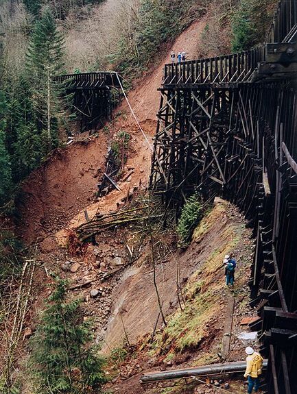
Portland General Electric (PGE) operated a 3.2-mile long flume that supplied water to a hydroelectric facility in the Sandy River watershed. During exceptional rainfall in February 1996, approximately 100 feet of the flume was destroyed by a debris flow landslide.
​
Landslide Technology was immediately retained by PGE to investigate the slide area and provide recommendations for repairing the flume. Landslide Technology conducted geologic reconnaissance and mapping, and developed a rockfill stabilization plan on the extremely steep slope. Difficult access required winching construction equipment down a cliff to the slide area, and removing the same equipment by helicopter airlift. The project was successfully completed ahead of PGE's desired schedule.

Services Provided:

  • Emergency response assessment
  • Geologic reconnaissance of landslide area
  • Landslide hazard mapping
  • Slope stability analyses
  • Technical assistance to owner during construction
Bull Run Flume Landslide
Proudly powered by Weebly
  • Home
  • Specialty Services
    • Geotech. Asset Mgmt. >
      • Montana Rock Slope Asset Mgmt. Program (RAMP)
      • Alaska Geotech Asset Mgmt
      • Ohio Landslide Inventory
    • Rope Access
    • 3D Modeling
    • Dam Safety & Slope Stability
    • Const. Sequence Modeling
    • Geotechnical Instrumentation
    • Construction Engineering
    • Expert Witness
  • Landslides
    • Hydropower >
      • Bull Run Flume
      • Swift Powerhouse
      • Frog Lake Dam Slide
    • Transportation >
      • Hwy 101 Johnson Creek
      • Looking Glass Hill Slides
      • SR 87 Arizona Slide
      • Togwotee Pass Road
      • Scoby Hill Landslide
      • Wrangell Airport
      • Snowbasin Access Road
      • Beartooth Debris Flows
      • Three Capes Scenic Loop Landslide
      • Richardson Hwy Slide
      • Bonners Ferry Landslide
      • Light Rail Station
      • Skagway Submarine Slide
    • Natural Resources >
      • West Africa Gas Pipeline
      • Greens Creek Mine Road
    • Private Clients >
      • Wasco County Landfill Landslide
  • Rock Slopes
    • Hydropower >
      • Biscuit Rock Rockslide
      • Skagit River Rockfall
      • JC Boyle Canal Rockfall
      • Prospect Dam Rockfall
      • Iron Gate Dam Rockfall
      • Cougar Dam Rockfall
    • Transportation >
      • I-15 (D3) Rock Slope Mitigation
      • Ketchikan Third Avenue
      • US Hwy 2 Libby Rockfall
      • Banks - Lowman Hwy
      • SR 191 Rock Cut Design
      • Going-to-the-Sun Road
      • SR 12 Rockfall Mitigation
      • Lakeside Rockfall
      • US 2 Badrock Canyon
      • South Tongass Highway
      • Weeksville Rock Bolting
      • US 26 Cove Palisades
  • Key Staff
    • Mike Meyer
    • Gerry Heslin
    • George Machan
    • Charlie Hammond
    • Brent Black
    • Darren Beckstrand
    • Chris Carpenter
    • Ben George
    • Wade Osborne
    • Tom Westover
    • Aine Mines
    • Adam Koslofsky
    • Logan Allender
    • Andy Kost
    • Collin McCormick
    • Anna Casady
    • Noah Kimmes
    • David LaPorte
    • Justin McCarley
    • Aleyna Donaldson
    • Michael Bunn
    • Andy Vessely
    • Larry Pierson
    • Derek Cornforth (Founder)
  • Resources
  • Contact Us