South Tongass Hwy Rockfall Mitigation
Ketchikan, Alaska
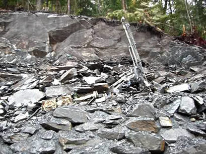 Drill Rig Buried by Rockfall
During the construction of a new cut slope, a large rockfall event from a partially completed cut face occurred, destroying the rock drill and posing a continuing safety hazard. Fortunately, no injuries resulted from the event. Following the event, Landslide Technology (LT) mobilized to the site between Christmas and New Years to provide emergency support to the Alaska Department of Transportation.
The base of the slope failure occurred along an adverse joint within an unanticipated diorite sill coupled with a tension crack that formed along the foliations in the overlying phyllite. Following a fast-tracked field investigation and analyses, mitigation required a redesign of the rock cut to include a mid-slope bench and the addition of multiple rock bolts.
At that time, LT was requested to evaluate the remaining rock cuts on the project. One 90-foot slope required a major redesign to prevent possible large scale planar failures from occurring along an adversely dipping joint set. During construction of both rock slopes, LT periodically performed on-site technical assistance to provide rock bolt location recommendations on newly exposed rock faces and guidance on proper rock bolt installation procedures.
Services Provided:
|
|