Old Hwy 224, Biscuit Rock Rockslide
Estacada, Oregon
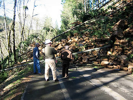 Rockslide Blocking an Access Road
The Faraday Hydroelectric Project on the Clackamas River has several hazards up slope of the facilities access road. Several rock slope failures have occurred at a location known as Biscuit Rock. An initial failure involved two 6-foot boulders and was associated with a period of intense rainfall. As they fell, the rocks struck and up-rooted several trees near the top of the road cut. The source of the rockfall was a tall basalt outcrop located about 100 feet above the road. Several large blocks from previous events were observed at the base of the outcrop and coupled with the recent event were strong indicators that the future stability of the outcrop should be a concern.
Following this event, Landslide Technology (LT) was authorized to inventory the slopes along the length of the road. LT's RHRS rankings indicated that this slope was one of the more hazardous on the roadway.
A second event occurred following another heavy rainfall event, where the entire slope failed. The failure was approximately 125 feet long, 90 feet wide, and had a volume of over 4,000 cubic yards. The rock blocks came from the columnar basalt referred to locally as the biscuit rocks and the upper more massive basalt outcrop. Blocks up to 15 feet in size were measured. Several smaller boulders reached the fish ladder located downslope of the road but did not cause any damage.
Due to the unstable nature of the upslope area and because slide debris completely covered the road, PGE elected to close the road and wait for better weather conditions before cleanup and mitigation measures were implemented. Prior to mitigation work, survey hubs, crackmeters, and extensometers anchor points were installed to monitor any slope movements during construction. Mitigation included removal of slide debris, reshaping of the lower portion of the slope, and construction of a free standing gabion wire wall (9 ft. tall by 10.5 ft. wide by 144 ft. long) on the inboard lane to provide containment and storage capacity for future rockfall and landslide events.
Services Provided:
|
|