Badrock Canyon Rock Joint Instrumentation
Columbia Falls, Montana
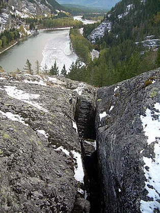 Deep Joint above Highway 2
Prior to Landslide Technology's involvement, the slopes in Badrock Canyon had been regularly monitored to detect block movements using dial gage, tape extensometer, and theodolite surveying techniques. This monitoring indicated seasonal fluctuations within the accuracy of the survey equipment. The Montana Department of Transportation wanted to continue monitoring with a more robust and precise rock slope monitoring system. They retained Landslide Technology (LT) to assess options.
LT installed separate electronic vibrating wire crackmeters (VWC) with dataloggers in three of the large bedrock tension cracks on the south side of the canyon. The dataloggers were set to record VWC measurements twice daily. Additionally, a terrestrial lidar survey program was initiated to detect movement of the face at selected rock outcrop locations above the road. Surveys and instrument readings have been carried out at regular bi-annual and annual intervals since installation. The inexpensive tape extensometer anchor points provide more complete coverage than the more expensive VWCs and scanning could allow.
The terrestrial lidar imagery was obtained near the road cut areas using a high point density. Subsequent scans are compared to prior readings for movement detection of key blocks.
The results of the automated vibrating wire crackmeter readings indicate a decrease in crack width during the summer and a width increase in winter. This likely corresponds to seasonal thermal expansion and contraction of the rock mass. However, a preliminary trend of very slow expansion of the joint year to year has been detected.
Services Provided:
|
|