LANDSLIDE TECHNOLOGY
  • Home
  • Landslides
    • Hydropower >
      • Bull Run Flume
      • Swift Powerhouse
      • Frog Lake Dam Slide
    • Transportation >
      • Hwy 101 Johnson Creek
      • Looking Glass Hill Slides
      • SR 87 Arizona Slide
      • Togwotee Pass Road
      • Scoby Hill Landslide
      • Wrangell Airport
      • Snowbasin Access Road
      • Beartooth Debris Flows
      • Three Capes Scenic Loop Landslide
      • Richardson Hwy Slide
      • Bonners Ferry Landslide
      • Light Rail Station
      • Skagway Submarine Slide
    • Natural Resources >
      • West Africa Gas Pipeline
      • Greens Creek Mine Road
    • Private Clients >
      • Wasco County Landfill Landslide
  • Rock Slopes
    • Hydropower >
      • Biscuit Rock Rockslide
      • Skagit River Rockfall
      • JC Boyle Canal Rockfall
      • Prospect Dam Rockfall
      • Iron Gate Dam Rockfall
      • Cougar Dam Rockfall
    • Transportation >
      • I-15 (D3) Rock Slope Mitigation
      • Ketchikan Third Avenue
      • US Hwy 2 Libby Rockfall
      • Banks - Lowman Hwy
      • SR 191 Rock Cut Design
      • Going-to-the-Sun Road
      • SR 12 Rockfall Mitigation
      • Lakeside Rockfall
      • US 2 Badrock Canyon
      • South Tongass Highway
      • Weeksville Rock Bolting
      • US 26 Cove Palisades
  • Specialty Services
    • Geotech. Asset Mgmt. >
      • Montana Rock Slope Asset Mgmt. Program (RAMP)
      • Alaska Geotech Asset Mgmt
      • Ohio Landslide Inventory
    • Rope Access
    • 3D Modeling
    • Dam Safety & Slope Stability
    • Const. Sequence Modeling
    • Geotechnical Instrumentation
    • Construction Engineering
    • Expert Witness
  • Staff
  • Resources
  • Careers
    • Geotechnical Engineer
  • Contact Us

Richardson Hwy MP 296 Landslide Mitigation

Richardson, Alaska
The Richardson Highway project is located on Alaska Highway 2 at Milepoint 296.3, which is about 60 miles east of Fairbanks along a stretch of steep side-hill cut/fill above the Tanana River.  A landslide affected approximately 140 feet of the highway.  Significant movement in the pavement was first identified in several years before remediation.  The rate of landslide movement accelerated over the following years resulting in roadway grading to maintain safe conditions for the travel public.

The portion of the landslide located above the highway is controlled by the bedrock structure and continues downslope into the river. Landslide Technology (LT) was retained to investigate the slide mechanism and to design potential mitigations.  LT performed a site reconnaissance, developed conceptual mitigation options, conducted rock strength testing, analysis and design, assisted in preparation of contract documents, and provided construction assistance for slide repair of the state highway. Remediation consisted of a ground anchor retaining walls located on both sides of the highway, which were designed to tolerate cold region conditions and constructed under traffic. LT developed a performance based bid package to utilize the expertise of the specialty contractor within the DOT's competitive bid process.

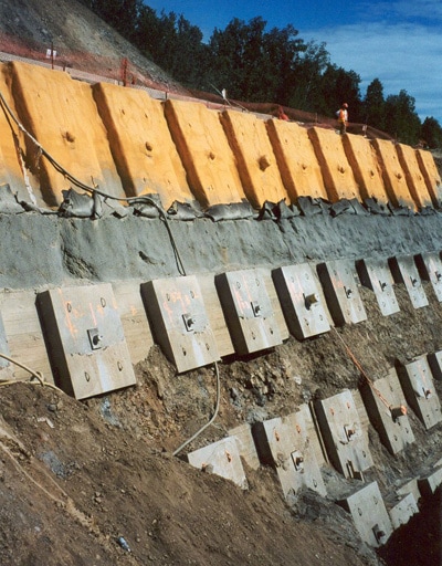
Ground Anchor Wall During Construction

Services Provided:

  • Geologic reconnaissance of landslide areas
  • Site investigations by borings
  • Landslide hazard mapping
  • Slope stability analyses
  • Evaluation of appropriate remedial options
  • ​Cost comparison of remedial alternatives
  • Final design of selected remedial measures
  • Development of Plans, Specifications & Engineers Estimate
  • Buttresses and retaining wall systems
  • Home
  • Landslides
    • Hydropower >
      • Bull Run Flume
      • Swift Powerhouse
      • Frog Lake Dam Slide
    • Transportation >
      • Hwy 101 Johnson Creek
      • Looking Glass Hill Slides
      • SR 87 Arizona Slide
      • Togwotee Pass Road
      • Scoby Hill Landslide
      • Wrangell Airport
      • Snowbasin Access Road
      • Beartooth Debris Flows
      • Three Capes Scenic Loop Landslide
      • Richardson Hwy Slide
      • Bonners Ferry Landslide
      • Light Rail Station
      • Skagway Submarine Slide
    • Natural Resources >
      • West Africa Gas Pipeline
      • Greens Creek Mine Road
    • Private Clients >
      • Wasco County Landfill Landslide
  • Rock Slopes
    • Hydropower >
      • Biscuit Rock Rockslide
      • Skagit River Rockfall
      • JC Boyle Canal Rockfall
      • Prospect Dam Rockfall
      • Iron Gate Dam Rockfall
      • Cougar Dam Rockfall
    • Transportation >
      • I-15 (D3) Rock Slope Mitigation
      • Ketchikan Third Avenue
      • US Hwy 2 Libby Rockfall
      • Banks - Lowman Hwy
      • SR 191 Rock Cut Design
      • Going-to-the-Sun Road
      • SR 12 Rockfall Mitigation
      • Lakeside Rockfall
      • US 2 Badrock Canyon
      • South Tongass Highway
      • Weeksville Rock Bolting
      • US 26 Cove Palisades
  • Specialty Services
    • Geotech. Asset Mgmt. >
      • Montana Rock Slope Asset Mgmt. Program (RAMP)
      • Alaska Geotech Asset Mgmt
      • Ohio Landslide Inventory
    • Rope Access
    • 3D Modeling
    • Dam Safety & Slope Stability
    • Const. Sequence Modeling
    • Geotechnical Instrumentation
    • Construction Engineering
    • Expert Witness
  • Staff
  • Resources
  • Careers
    • Geotechnical Engineer
  • Contact Us