Landslide Technology
  • Home
  • Specialty Services
    • Geotech. Asset Mgmt. >
      • Montana Rock Slope Asset Mgmt. Program (RAMP)
      • Alaska Geotech Asset Mgmt
      • Ohio Landslide Inventory
    • Rope Access
    • 3D Modeling
    • Dam Safety & Slope Stability
    • Const. Sequence Modeling
    • Geotechnical Instrumentation
    • Construction Engineering
    • Expert Witness
  • Landslides
    • Hydropower >
      • Bull Run Flume
      • Swift Powerhouse
      • Frog Lake Dam Slide
    • Transportation >
      • Hwy 101 Johnson Creek
      • Looking Glass Hill Slides
      • SR 87 Arizona Slide
      • Togwotee Pass Road
      • Scoby Hill Landslide
      • Wrangell Airport
      • Snowbasin Access Road
      • Beartooth Debris Flows
      • Three Capes Scenic Loop Landslide
      • Richardson Hwy Slide
      • Bonners Ferry Landslide
      • Light Rail Station
      • Skagway Submarine Slide
    • Natural Resources >
      • West Africa Gas Pipeline
      • Greens Creek Mine Road
    • Private Clients >
      • Wasco County Landfill Landslide
  • Rock Slopes
    • Hydropower >
      • Biscuit Rock Rockslide
      • Skagit River Rockfall
      • JC Boyle Canal Rockfall
      • Prospect Dam Rockfall
      • Iron Gate Dam Rockfall
      • Cougar Dam Rockfall
    • Transportation >
      • I-15 (D3) Rock Slope Mitigation
      • Ketchikan Third Avenue
      • US Hwy 2 Libby Rockfall
      • Banks - Lowman Hwy
      • SR 191 Rock Cut Design
      • Going-to-the-Sun Road
      • SR 12 Rockfall Mitigation
      • Lakeside Rockfall
      • US 2 Badrock Canyon
      • South Tongass Highway
      • Weeksville Rock Bolting
      • US 26 Cove Palisades
  • Key Staff
    • Mike Meyer
    • Gerry Heslin
    • George Machan
    • Charlie Hammond
    • Brent Black
    • Darren Beckstrand
    • Chris Carpenter
    • Ben George
    • Wade Osborne
    • Tom Westover
    • Aine Mines
    • Adam Koslofsky
    • Logan Allender
    • Andy Kost
    • Collin McCormick
    • Anna Casady
    • Noah Kimmes
    • David LaPorte
    • Justin McCarley
    • Aleyna Donaldson
    • Michael Bunn
    • Andy Vessely
    • Larry Pierson
    • Derek Cornforth (Founder)
  • Resources
  • Contact Us

3D Surface Modeling, Change Detection, & Geologic Analysis


Landslide Technology's experts in geomorphology have developed techniques for comparisons of various surface data sources, including aerial and terrestrial LiDAR and state-of-the-art photogrammetric methods.  A sample video is provided below.  These comparative techniques are excellent for detecting rockfall activity, landslide movement, remote discontinuity measurements, rock slope scaling effectiveness, and spillway safety. 
Picture
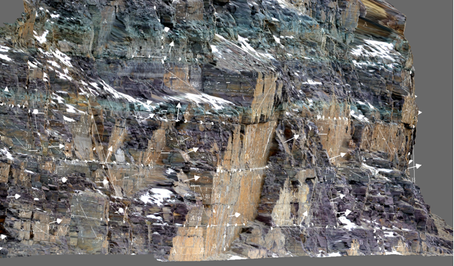
3D Photogrammetry Model
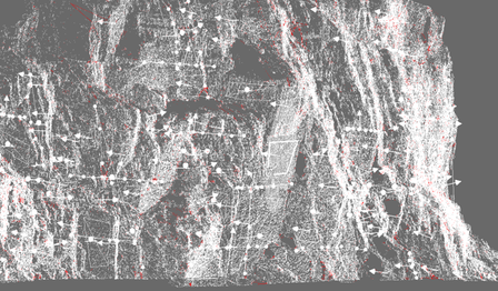
Picture
3D Mesh Model

Representative Projects:

  • Iron Gate Dam, Hornbrook, California 
  • Yale Spillway Rock Slope Stability Analysis, Cougar, Washington
  • Little River Road, Douglas County, Oregon
  • D3 Rockfall Mitigation, Helena, Montana
  • Seward Highway Rockfall Mitigation, Anchorage, Alaska
  • Mobridge Slide Geotechnical Study, Lewistown, Montana
  • Madison River Corridor Study, Norris, Montana
  • Historic Columbia River Highway Trail, Oregon
  • Powerhouse Slope Evaluation, Washington
  • Parks Highway Slope Scaling, Healy, Alaska
  • District 1 Landslides, Idaho Transportation Department
  • Rattlesnake Hills Landslide Characterization
  • I-90 Rockfall Mitigation, St. Regis, Montana

3D Modeling and Analysis Services Offered:

  • Spillway rock slope stability and potential failure mode (PFM) evaluation
  • Rock slope geologic characterization
  • ​Rock slope scaling inspection​
  • Landslide characterization and mapping
  • Rock slope and landslide change detection
  • Topographic map preparation
  • Rock slope cross section development

Proudly powered by Weebly
  • Home
  • Specialty Services
    • Geotech. Asset Mgmt. >
      • Montana Rock Slope Asset Mgmt. Program (RAMP)
      • Alaska Geotech Asset Mgmt
      • Ohio Landslide Inventory
    • Rope Access
    • 3D Modeling
    • Dam Safety & Slope Stability
    • Const. Sequence Modeling
    • Geotechnical Instrumentation
    • Construction Engineering
    • Expert Witness
  • Landslides
    • Hydropower >
      • Bull Run Flume
      • Swift Powerhouse
      • Frog Lake Dam Slide
    • Transportation >
      • Hwy 101 Johnson Creek
      • Looking Glass Hill Slides
      • SR 87 Arizona Slide
      • Togwotee Pass Road
      • Scoby Hill Landslide
      • Wrangell Airport
      • Snowbasin Access Road
      • Beartooth Debris Flows
      • Three Capes Scenic Loop Landslide
      • Richardson Hwy Slide
      • Bonners Ferry Landslide
      • Light Rail Station
      • Skagway Submarine Slide
    • Natural Resources >
      • West Africa Gas Pipeline
      • Greens Creek Mine Road
    • Private Clients >
      • Wasco County Landfill Landslide
  • Rock Slopes
    • Hydropower >
      • Biscuit Rock Rockslide
      • Skagit River Rockfall
      • JC Boyle Canal Rockfall
      • Prospect Dam Rockfall
      • Iron Gate Dam Rockfall
      • Cougar Dam Rockfall
    • Transportation >
      • I-15 (D3) Rock Slope Mitigation
      • Ketchikan Third Avenue
      • US Hwy 2 Libby Rockfall
      • Banks - Lowman Hwy
      • SR 191 Rock Cut Design
      • Going-to-the-Sun Road
      • SR 12 Rockfall Mitigation
      • Lakeside Rockfall
      • US 2 Badrock Canyon
      • South Tongass Highway
      • Weeksville Rock Bolting
      • US 26 Cove Palisades
  • Key Staff
    • Mike Meyer
    • Gerry Heslin
    • George Machan
    • Charlie Hammond
    • Brent Black
    • Darren Beckstrand
    • Chris Carpenter
    • Ben George
    • Wade Osborne
    • Tom Westover
    • Aine Mines
    • Adam Koslofsky
    • Logan Allender
    • Andy Kost
    • Collin McCormick
    • Anna Casady
    • Noah Kimmes
    • David LaPorte
    • Justin McCarley
    • Aleyna Donaldson
    • Michael Bunn
    • Andy Vessely
    • Larry Pierson
    • Derek Cornforth (Founder)
  • Resources
  • Contact Us