LANDSLIDE TECHNOLOGY
  • Home
  • Landslides
    • Hydropower >
      • Bull Run Flume
      • Swift Powerhouse
      • Frog Lake Dam Slide
    • Transportation >
      • Hwy 101 Johnson Creek
      • Looking Glass Hill Slides
      • SR 87 Arizona Slide
      • Togwotee Pass Road
      • Scoby Hill Landslide
      • Wrangell Airport
      • Snowbasin Access Road
      • Beartooth Debris Flows
      • Three Capes Scenic Loop Landslide
      • Richardson Hwy Slide
      • Bonners Ferry Landslide
      • Light Rail Station
      • Skagway Submarine Slide
    • Natural Resources >
      • West Africa Gas Pipeline
      • Greens Creek Mine Road
    • Private Clients >
      • Wasco County Landfill Landslide
  • Rock Slopes
    • Hydropower >
      • Biscuit Rock Rockslide
      • Skagit River Rockfall
      • JC Boyle Canal Rockfall
      • Prospect Dam Rockfall
      • Iron Gate Dam Rockfall
      • Cougar Dam Rockfall
    • Transportation >
      • I-15 (D3) Rock Slope Mitigation
      • Ketchikan Third Avenue
      • US Hwy 2 Libby Rockfall
      • Banks - Lowman Hwy
      • SR 191 Rock Cut Design
      • Going-to-the-Sun Road
      • SR 12 Rockfall Mitigation
      • Lakeside Rockfall
      • US 2 Badrock Canyon
      • South Tongass Highway
      • Weeksville Rock Bolting
      • US 26 Cove Palisades
  • Specialty Services
    • Geotech. Asset Mgmt. >
      • Montana Rock Slope Asset Mgmt. Program (RAMP)
      • Alaska Geotech Asset Mgmt
      • Ohio Landslide Inventory
    • Rope Access
    • 3D Modeling
    • Dam Safety & Slope Stability
    • Const. Sequence Modeling
    • Geotechnical Instrumentation
    • Construction Engineering
    • Expert Witness
  • Staff
  • Resources
  • Careers
    • Geotechnical Engineer
  • Contact Us

SR 12 White Pass Rockfall Mitigation 

White Pass, Washington
Investigation at the First of Three Sites
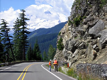
Field Investigation at the First of Three Sites
Washington State Route 12 bisects the Cascades in southern Washington.  Several portions of the highway were identified for potential rockfall mitigation as part of the White Pass Unstable Slopes Corridor Project.  In 2005, Landslide Technology (LT) was retained by WSDOT to evaluate three sites and develop rockfall mitigation plans. 

LT geologists performed geologic field reconnaissance, mapped geologic structural features (i.e. rock discontinuities such as joints, fractures, faults, etc.), conducted kinematic analyses of the rock discontinuity data, modeled stability failure modes, and conducted laboratory testing to determine physical and engineering properties of representative samples. 

The results of the investigations and analyses were used to develop rockfall mitigation measures including tree cutting, hand and mechanical scaling, cable lashing, bolting key rock blocks, draped mesh, modified cable net fences, concrete barriers, improved ditch/fallout areas, and controlled blasting.  LT completed final design on the measures and prepared Special Provisions to supplement the WSDOT Standard Specifications. Construction was completed in the summer of 2006.


Services Provided:

  • Rockfall Hazard Assessment
  • Rockfall Mitigation
  • Rockfall Barrier and Draped Mesh Design


  • Slope Stability Modeling
  • Laboratory Testing
  • Hazardous Rock Removal


  • Home
  • Landslides
    • Hydropower >
      • Bull Run Flume
      • Swift Powerhouse
      • Frog Lake Dam Slide
    • Transportation >
      • Hwy 101 Johnson Creek
      • Looking Glass Hill Slides
      • SR 87 Arizona Slide
      • Togwotee Pass Road
      • Scoby Hill Landslide
      • Wrangell Airport
      • Snowbasin Access Road
      • Beartooth Debris Flows
      • Three Capes Scenic Loop Landslide
      • Richardson Hwy Slide
      • Bonners Ferry Landslide
      • Light Rail Station
      • Skagway Submarine Slide
    • Natural Resources >
      • West Africa Gas Pipeline
      • Greens Creek Mine Road
    • Private Clients >
      • Wasco County Landfill Landslide
  • Rock Slopes
    • Hydropower >
      • Biscuit Rock Rockslide
      • Skagit River Rockfall
      • JC Boyle Canal Rockfall
      • Prospect Dam Rockfall
      • Iron Gate Dam Rockfall
      • Cougar Dam Rockfall
    • Transportation >
      • I-15 (D3) Rock Slope Mitigation
      • Ketchikan Third Avenue
      • US Hwy 2 Libby Rockfall
      • Banks - Lowman Hwy
      • SR 191 Rock Cut Design
      • Going-to-the-Sun Road
      • SR 12 Rockfall Mitigation
      • Lakeside Rockfall
      • US 2 Badrock Canyon
      • South Tongass Highway
      • Weeksville Rock Bolting
      • US 26 Cove Palisades
  • Specialty Services
    • Geotech. Asset Mgmt. >
      • Montana Rock Slope Asset Mgmt. Program (RAMP)
      • Alaska Geotech Asset Mgmt
      • Ohio Landslide Inventory
    • Rope Access
    • 3D Modeling
    • Dam Safety & Slope Stability
    • Const. Sequence Modeling
    • Geotechnical Instrumentation
    • Construction Engineering
    • Expert Witness
  • Staff
  • Resources
  • Careers
    • Geotechnical Engineer
  • Contact Us