LANDSLIDE TECHNOLOGY
  • Home
  • Landslides
    • Hydropower >
      • Bull Run Flume
      • Swift Powerhouse
      • Frog Lake Dam Slide
    • Transportation >
      • Hwy 101 Johnson Creek
      • Looking Glass Hill Slides
      • SR 87 Arizona Slide
      • Togwotee Pass Road
      • Scoby Hill Landslide
      • Wrangell Airport
      • Snowbasin Access Road
      • Beartooth Debris Flows
      • Three Capes Scenic Loop Landslide
      • Richardson Hwy Slide
      • Bonners Ferry Landslide
      • Light Rail Station
      • Skagway Submarine Slide
    • Natural Resources >
      • West Africa Gas Pipeline
      • Greens Creek Mine Road
    • Private Clients >
      • Wasco County Landfill Landslide
  • Rock Slopes
    • Hydropower >
      • Biscuit Rock Rockslide
      • Skagit River Rockfall
      • JC Boyle Canal Rockfall
      • Prospect Dam Rockfall
      • Iron Gate Dam Rockfall
      • Cougar Dam Rockfall
    • Transportation >
      • I-15 (D3) Rock Slope Mitigation
      • Ketchikan Third Avenue
      • US Hwy 2 Libby Rockfall
      • Banks - Lowman Hwy
      • SR 191 Rock Cut Design
      • Going-to-the-Sun Road
      • SR 12 Rockfall Mitigation
      • Lakeside Rockfall
      • US 2 Badrock Canyon
      • South Tongass Highway
      • Weeksville Rock Bolting
      • US 26 Cove Palisades
  • Specialty Services
    • Geotech. Asset Mgmt. >
      • Montana Rock Slope Asset Mgmt. Program (RAMP)
      • Alaska Geotech Asset Mgmt
      • Ohio Landslide Inventory
    • Rope Access
    • 3D Modeling
    • Dam Safety & Slope Stability
    • Const. Sequence Modeling
    • Geotechnical Instrumentation
    • Construction Engineering
    • Expert Witness
  • Staff
  • Resources
  • Careers
    • Geotechnical Engineer
  • Contact Us

MT Hwy 49, Looking Glass Hill Roadway Landslide and Rockfall

East Glacier Park, Montana
Montana highway MT 49, known locally as Looking Glass Hill Road, is a significant traffic corridor for Glacier National Park traffic that links the Two Medicine recreation area with St. Mary Lake and the east entrance to the Going to the Sun Road. Even though it is only seasonally open, the National Park Lodge and local businesses rely heavily on travelers using the highway.

The slope stability problems within the project limits include numerous landslides and rockfalls that are detrimental to the function of the roadway and require extensive and regular maintenance. Maintenance includes reestablishment of the road's horizontal and vertical alignments through landslide sections, and removal of substantial accumulations of rockfall debris annually and as part of routine road patrols.

Based on the FHWA emergency relief evaluations, eight of the slope stability problem areas between MP 4.6 to 10.0 were identified as emergency sites. Based on this finding, Landslide Technology was retained to perform the field analysis and generate landslide and rockfall mitigation measures.

The project was conducted in two phases. Phase 1 consisted of a preliminary aerial and ground reconnaissance and an initial subsurface investigation and instrumentation program to identify the types of landslide movements including typical depths and rates. Phase 2 included an expanded exploration program, instrument monitoring, geotechnical analyses, and development of mitigation design concepts. Overall, 29 inclinometer and piezometer borings representing over 1,800 feet of drilling were installed and monitored for the duration of the project.

Recommended landslide mitigation measures included rock buttresses, MSE walls, tieback walls, stone column shear keys, and bench cut realignments. Rockfall mitigation measures included scaling, modified rockfall fences, ditch improvements, rock bolting, and roadway realignment.
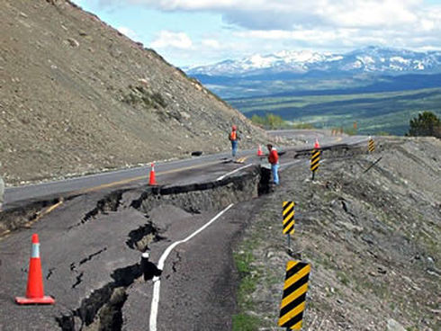
Inspection of the Failed Roadway

Services Provided:

  • Geologic reconnaissance of landslide areas
  • Landslide Hazard Mapping
  • Site investigations by borings
  • Landslide Instrumentation
  • Slope Stability analyses
  • Evaluation of appropriate remedial options
  • Cost comparison of remedial alternatives
  • Home
  • Landslides
    • Hydropower >
      • Bull Run Flume
      • Swift Powerhouse
      • Frog Lake Dam Slide
    • Transportation >
      • Hwy 101 Johnson Creek
      • Looking Glass Hill Slides
      • SR 87 Arizona Slide
      • Togwotee Pass Road
      • Scoby Hill Landslide
      • Wrangell Airport
      • Snowbasin Access Road
      • Beartooth Debris Flows
      • Three Capes Scenic Loop Landslide
      • Richardson Hwy Slide
      • Bonners Ferry Landslide
      • Light Rail Station
      • Skagway Submarine Slide
    • Natural Resources >
      • West Africa Gas Pipeline
      • Greens Creek Mine Road
    • Private Clients >
      • Wasco County Landfill Landslide
  • Rock Slopes
    • Hydropower >
      • Biscuit Rock Rockslide
      • Skagit River Rockfall
      • JC Boyle Canal Rockfall
      • Prospect Dam Rockfall
      • Iron Gate Dam Rockfall
      • Cougar Dam Rockfall
    • Transportation >
      • I-15 (D3) Rock Slope Mitigation
      • Ketchikan Third Avenue
      • US Hwy 2 Libby Rockfall
      • Banks - Lowman Hwy
      • SR 191 Rock Cut Design
      • Going-to-the-Sun Road
      • SR 12 Rockfall Mitigation
      • Lakeside Rockfall
      • US 2 Badrock Canyon
      • South Tongass Highway
      • Weeksville Rock Bolting
      • US 26 Cove Palisades
  • Specialty Services
    • Geotech. Asset Mgmt. >
      • Montana Rock Slope Asset Mgmt. Program (RAMP)
      • Alaska Geotech Asset Mgmt
      • Ohio Landslide Inventory
    • Rope Access
    • 3D Modeling
    • Dam Safety & Slope Stability
    • Const. Sequence Modeling
    • Geotechnical Instrumentation
    • Construction Engineering
    • Expert Witness
  • Staff
  • Resources
  • Careers
    • Geotechnical Engineer
  • Contact Us