Ketchikan Third Avenue Extension
Ketchikan, Alaska
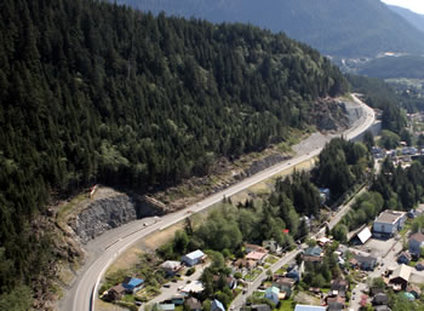 Completed Third Avenue Rockcuts, Debris Flow Mitigation and RCC Retaining Wall
To bypass a traffic constriction in the middle of the City of Ketchikan, Alaska Department of Transportation constructed a new roadway high on a steep slope. The Third Avenue Extension project involved a completely new roadway crossing very steep ground immediately upslope (within 150 feet) of Ketchikan residences. The road alignment crosses a prominent rock escarpment, requiring rock cut slopes for the new grade of up to 110 feet tall. The alignment also crosses steep side hill colluvium slopes and a 400-foot wide debris slide.
Landslide Technology was retained by Alaska DOT&PF to assist with geotechnical investigation and design of rock cuts, rock slope stability, excavation staging, control methods for rockfall resulting from blasting and other construction activities, structure and foundation recommendations, rock blasting, and stability evaluation of embankments and walls crossing the debris flow area. Landslide Technology performed reconnaissance, rock structure mapping, extensive subsurface investigation and instrumentation, rock slope and debris flow stability analysis, rockfall simulation analyses, a constructibility evaluation, and assisted on PS&E.
A key feature of the project included an innovative design for a roller compacted concrete (RCC) retaining wall, which measured 1,000 feet in length and up to 90 feet in height. The RCC wall provided the downhill residences with rock fall-out protection during the excavation and blasting, and supports an elevated portion of the roadway. Rockfall mitigation included 20 and 30-foot long, high capacity rock bolts and Brugg rockfall barrier systems. An unstable 5,000-ton rock block immediately uphill of residences required specific design and staged excavation to remove safely.
Services Provided:
|
|