Landslide Technology
  • Home
  • Specialty Services
    • Geotech. Asset Mgmt. >
      • Montana Rock Slope Asset Mgmt. Program (RAMP)
      • Alaska Geotech Asset Mgmt
      • Ohio Landslide Inventory
    • Rope Access
    • 3D Modeling
    • Dam Safety & Slope Stability
    • Const. Sequence Modeling
    • Geotechnical Instrumentation
    • Construction Engineering
    • Expert Witness
  • Landslides
    • Hydropower >
      • Bull Run Flume
      • Swift Powerhouse
      • Frog Lake Dam Slide
    • Transportation >
      • Hwy 101 Johnson Creek
      • Looking Glass Hill Slides
      • SR 87 Arizona Slide
      • Togwotee Pass Road
      • Scoby Hill Landslide
      • Wrangell Airport
      • Snowbasin Access Road
      • Beartooth Debris Flows
      • Three Capes Scenic Loop Landslide
      • Richardson Hwy Slide
      • Bonners Ferry Landslide
      • Light Rail Station
      • Skagway Submarine Slide
    • Natural Resources >
      • West Africa Gas Pipeline
      • Greens Creek Mine Road
    • Private Clients >
      • Wasco County Landfill Landslide
  • Rock Slopes
    • Hydropower >
      • Biscuit Rock Rockslide
      • Skagit River Rockfall
      • JC Boyle Canal Rockfall
      • Prospect Dam Rockfall
      • Iron Gate Dam Rockfall
      • Cougar Dam Rockfall
    • Transportation >
      • I-15 (D3) Rock Slope Mitigation
      • Ketchikan Third Avenue
      • US Hwy 2 Libby Rockfall
      • Banks - Lowman Hwy
      • SR 191 Rock Cut Design
      • Going-to-the-Sun Road
      • SR 12 Rockfall Mitigation
      • Lakeside Rockfall
      • US 2 Badrock Canyon
      • South Tongass Highway
      • Weeksville Rock Bolting
      • US 26 Cove Palisades
  • Key Staff
    • Mike Meyer
    • Gerry Heslin
    • George Machan
    • Charlie Hammond
    • Brent Black
    • Darren Beckstrand
    • Chris Carpenter
    • Ben George
    • Wade Osborne
    • Tom Westover
    • Aine Mines
    • Adam Koslofsky
    • Logan Allender
    • Andy Kost
    • Collin McCormick
    • Anna Casady
    • Noah Kimmes
    • David LaPorte
    • Justin McCarley
    • Aleyna Donaldson
    • Michael Bunn
    • Andy Vessely
    • Larry Pierson
    • Derek Cornforth (Founder)
  • Resources
  • Contact Us

State Route 87 Landslides

Payson, Arizona
Arizona Department of Transportation (ADOT) designed and administered construction of a five mile realignment of SR 87 to allow for expansion of the highway from two to four lanes and to bypass Sycamore Creek north of Sunflower, Arizona.  Several geotechnical on-call consultants to ADOT conducted investigations of proposed alignments with the final alignment being selected to avoid known landslides.   The design called for significant cut and fill sections passing through the Tonto National Forest.  To reduce environmental impacts within forest lands, two double-tiered soil nail walls (Walls 1 and 2) and two single-tiered soil-nail walls (Walls 3 and 4) were included as part of the design.  

Additional slope failures occurred at each of the soil-nail walls prompting mitigative efforts.  Mitigation included removing the upper tier of Wall 1, flattening the slope above the upper tier of Wall 2, conducting minor slope repairs at the base of Wall 3, and completely removing Wall 4.  These efforts stabilized the slopes until additional movement occurred.  Emergency mitigation included construction of an H-pile shear wall at the toe of the slope beneath Walls 3 and 4.  Prior to completing the shear pile wall additional movement occurred potentially compromising the mitigative efforts.  This movement consisted of about 3 feet of lateral displacement at the southbound fogline and up to 3 feet of pavement heave.  Deformations were also observed at Walls 1 and 2.  Initial response consisted of flattening the cut slope to a 3.5H:1V and completing the H-pile shear wall.  However, slide movements continued.

Landslide Technology (LT) was later contracted by AECOM (on behalf of ADOT) to independently evaluate the mechanisms of the local slope failures, assess the risk of additional local failures, and estimate the stability of the global (ancient) landslide.  LT estimated the local slides and wall failures were occurring due to strain softening as a result of deep excavations for the highway thru-cut removing confining stresses in turn allowing rebound to occur. Recommendations were provided for additional field explorations, geotechnical instrumentation, and monitoring at locations in and around the failures.  The supplemental data resulted in improved geologic models for global and local slide geometries, estimated residual shear strengths of 7 to 13 degrees for the shear zone materials (which were verified with ring shear tests), small groundwater head pressures along the shear zone measured in piezometers, and confirmation that the larger ancient slide was not currently moving. 

The information gathered from the supplemental investigations and analyses was used by LT and AECOM to provide design recommendations for several mitigative options and allowed for evaluation of associated risks.  Mitigation at the slide comprising Walls 3 and 4 consisted of large diameter (5.5-foot) concrete shear piles and a toe buttress.  Preliminary analyses were also performed for future mitigation at Walls 1 and 2.  Mitigation options include shear piles, ground anchors, larger buttresses, unloading, and shifting the highway alignment 20 to 40 feet east.
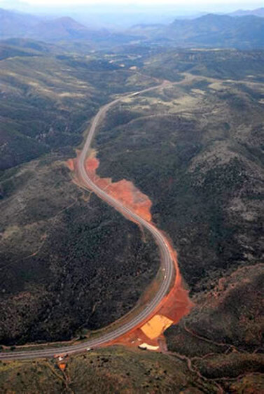
Oblique Aerial View of SR 87 Landslide Areas

Services Provided:

  • Geologic reconnaissance of landslide areas
  • Landslide Hazard Mapping
  • Site investigations by borings
  • Landslide Instrumentation
  • Slope Stability analyses
  • Evaluation of appropriate remedial options
  • Cost comparison of remedial alternatives
  • Buttresses and retaining wall systems
Proudly powered by Weebly
  • Home
  • Specialty Services
    • Geotech. Asset Mgmt. >
      • Montana Rock Slope Asset Mgmt. Program (RAMP)
      • Alaska Geotech Asset Mgmt
      • Ohio Landslide Inventory
    • Rope Access
    • 3D Modeling
    • Dam Safety & Slope Stability
    • Const. Sequence Modeling
    • Geotechnical Instrumentation
    • Construction Engineering
    • Expert Witness
  • Landslides
    • Hydropower >
      • Bull Run Flume
      • Swift Powerhouse
      • Frog Lake Dam Slide
    • Transportation >
      • Hwy 101 Johnson Creek
      • Looking Glass Hill Slides
      • SR 87 Arizona Slide
      • Togwotee Pass Road
      • Scoby Hill Landslide
      • Wrangell Airport
      • Snowbasin Access Road
      • Beartooth Debris Flows
      • Three Capes Scenic Loop Landslide
      • Richardson Hwy Slide
      • Bonners Ferry Landslide
      • Light Rail Station
      • Skagway Submarine Slide
    • Natural Resources >
      • West Africa Gas Pipeline
      • Greens Creek Mine Road
    • Private Clients >
      • Wasco County Landfill Landslide
  • Rock Slopes
    • Hydropower >
      • Biscuit Rock Rockslide
      • Skagit River Rockfall
      • JC Boyle Canal Rockfall
      • Prospect Dam Rockfall
      • Iron Gate Dam Rockfall
      • Cougar Dam Rockfall
    • Transportation >
      • I-15 (D3) Rock Slope Mitigation
      • Ketchikan Third Avenue
      • US Hwy 2 Libby Rockfall
      • Banks - Lowman Hwy
      • SR 191 Rock Cut Design
      • Going-to-the-Sun Road
      • SR 12 Rockfall Mitigation
      • Lakeside Rockfall
      • US 2 Badrock Canyon
      • South Tongass Highway
      • Weeksville Rock Bolting
      • US 26 Cove Palisades
  • Key Staff
    • Mike Meyer
    • Gerry Heslin
    • George Machan
    • Charlie Hammond
    • Brent Black
    • Darren Beckstrand
    • Chris Carpenter
    • Ben George
    • Wade Osborne
    • Tom Westover
    • Aine Mines
    • Adam Koslofsky
    • Logan Allender
    • Andy Kost
    • Collin McCormick
    • Anna Casady
    • Noah Kimmes
    • David LaPorte
    • Justin McCarley
    • Aleyna Donaldson
    • Michael Bunn
    • Andy Vessely
    • Larry Pierson
    • Derek Cornforth (Founder)
  • Resources
  • Contact Us