Hwy 2 Rockfall Mitigation
Libby, Montana
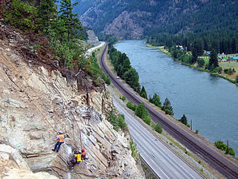 Scaling 250 feet above Highway 2 and BNSF Railroad
A wedge failure developed in a new rock cut slope along U.S. Highway 2 west of Libby soon after construction. Within ten years, the wedge failure had retrogressed beyond the crest of the original cut slope to form a trough, extending approximately 130 feet into the slope that was over 150 feet wide and nearly 200 feet high. Due to the slope height, continuing rockfall activity, concerns for worker and traffic safety, and a history of vehicle involvement; the Montana Department of Transporation (MDT) retained Landslide Technology (LT) to develop mitigation measures to reduce rockfall hazards. Tasks included detailed geologic and rock structural mapping, rockmass characterization, stability analyses, computer rockfall simulations, and development of rockfall mitigation measures.
Mitigation measures included scaling, shotcreting, rock bolts, draped ring nets, and a rockfall barrier fence. LT developed final design plans and special provisions were developed for MDT to include in bid package documents. Following the bid letting, LT provided continuous technical support during construction activities.
Mitigation measures included scaling, shotcreting, rock bolts, draped ring nets, and a rockfall barrier fence. LT developed final design plans and special provisions were developed for MDT to include in bid package documents. Following the bid letting, LT provided continuous technical support during construction activities.
Services Provided:
|
|