LANDSLIDE TECHNOLOGY
  • Home
  • Landslides
    • Hydropower >
      • Bull Run Flume
      • Swift Powerhouse
      • Frog Lake Dam Slide
    • Transportation >
      • Hwy 101 Johnson Creek
      • Looking Glass Hill Slides
      • SR 87 Arizona Slide
      • Togwotee Pass Road
      • Scoby Hill Landslide
      • Wrangell Airport
      • Snowbasin Access Road
      • Beartooth Debris Flows
      • Three Capes Scenic Loop Landslide
      • Richardson Hwy Slide
      • Bonners Ferry Landslide
      • Light Rail Station
      • Skagway Submarine Slide
    • Natural Resources >
      • West Africa Gas Pipeline
      • Greens Creek Mine Road
    • Private Clients >
      • Wasco County Landfill Landslide
  • Rock Slopes
    • Hydropower >
      • Biscuit Rock Rockslide
      • Skagit River Rockfall
      • JC Boyle Canal Rockfall
      • Prospect Dam Rockfall
      • Iron Gate Dam Rockfall
      • Cougar Dam Rockfall
    • Transportation >
      • I-15 (D3) Rock Slope Mitigation
      • Ketchikan Third Avenue
      • US Hwy 2 Libby Rockfall
      • Banks - Lowman Hwy
      • SR 191 Rock Cut Design
      • Going-to-the-Sun Road
      • SR 12 Rockfall Mitigation
      • Lakeside Rockfall
      • US 2 Badrock Canyon
      • South Tongass Highway
      • Weeksville Rock Bolting
      • US 26 Cove Palisades
  • Specialty Services
    • Geotech. Asset Mgmt. >
      • Montana Rock Slope Asset Mgmt. Program (RAMP)
      • Alaska Geotech Asset Mgmt
      • Ohio Landslide Inventory
    • Rope Access
    • 3D Modeling
    • Dam Safety & Slope Stability
    • Const. Sequence Modeling
    • Geotechnical Instrumentation
    • Construction Engineering
    • Expert Witness
  • Staff
  • Resources
  • Careers
    • Geotechnical Engineer
  • Contact Us

Hwy 26/287 Rosie's Ridge and Togwotee Pass Landslides

Dubois, Wyoming
US-26/287 is the most direct route for accessing the Grand Teton National Park from central and southeastern Wyoming. Locally it is referred to as the Togwotee Trail, named after the Togwotee Pass, which is at an approximate elevation of 9,700 feet, and is part of the Centennial Scenic Byway. The highway was originally built between 1955 and 1967 by the U.S. Bureau of Public Roads with various repairs and upgrades occurring periodically since that time.
​
The Wyoming Department of Transportation (WYDOT) identified a 21-mile segment along the roadway between Moran Junction and Dubois that was in need of major roadway improvements. Approximately 20 landslides were also observed within the outlined segment. WYDOT conducted subsurface investigations and designed roadway improvement measures.

​Landslide Technology (LT) was retained to assist with geologic reconnaissance and interpretations, evaluate landslide features, review potential slope instability, and develop conceptual-level landslide mitigation measures. Recommendations were provided for additional field explorations, geotechnical instrumentation, and monitoring at selected sites along the alignment. The additional explorations and instrumentation allowed LT and WYDOT to refine the geologic interpretations for slope stability modeling input. LT completed initial stability analyses to evaluate potential mitigation measures that included: toe berms, shear keys, rock inlays, trench drains, retaining wall structures, lightweight fills, and horizontal drain arrays. Preliminary cost estimates were prepared for construction of each alternative.

Once WYDOT selected landslide mitigation measures for each slide, LT prepared recommendations for final designs, technical specifications, and engineer’s estimates. LT was also retained to train WYDOT inspectors and provide part-time construction observation of landslide repairs including horizontal drains, shear keys, buttresses, EPS (Geofoam) fills, and post-tensioned ground anchors.
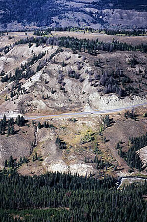
Landslide Segment on Highway 26

Services Provided:

  • Geologic reconnaissance of landslide areas
  • Slope stability analyses
  • Evaluation of appropriate remedial options
  • Cost comparison of remedial alternatives
  • Dewatering system design
  • Butresses and retaining wall systems
  • Final Design of remedial options
  • Technical assistance to owner during construction
  • Home
  • Landslides
    • Hydropower >
      • Bull Run Flume
      • Swift Powerhouse
      • Frog Lake Dam Slide
    • Transportation >
      • Hwy 101 Johnson Creek
      • Looking Glass Hill Slides
      • SR 87 Arizona Slide
      • Togwotee Pass Road
      • Scoby Hill Landslide
      • Wrangell Airport
      • Snowbasin Access Road
      • Beartooth Debris Flows
      • Three Capes Scenic Loop Landslide
      • Richardson Hwy Slide
      • Bonners Ferry Landslide
      • Light Rail Station
      • Skagway Submarine Slide
    • Natural Resources >
      • West Africa Gas Pipeline
      • Greens Creek Mine Road
    • Private Clients >
      • Wasco County Landfill Landslide
  • Rock Slopes
    • Hydropower >
      • Biscuit Rock Rockslide
      • Skagit River Rockfall
      • JC Boyle Canal Rockfall
      • Prospect Dam Rockfall
      • Iron Gate Dam Rockfall
      • Cougar Dam Rockfall
    • Transportation >
      • I-15 (D3) Rock Slope Mitigation
      • Ketchikan Third Avenue
      • US Hwy 2 Libby Rockfall
      • Banks - Lowman Hwy
      • SR 191 Rock Cut Design
      • Going-to-the-Sun Road
      • SR 12 Rockfall Mitigation
      • Lakeside Rockfall
      • US 2 Badrock Canyon
      • South Tongass Highway
      • Weeksville Rock Bolting
      • US 26 Cove Palisades
  • Specialty Services
    • Geotech. Asset Mgmt. >
      • Montana Rock Slope Asset Mgmt. Program (RAMP)
      • Alaska Geotech Asset Mgmt
      • Ohio Landslide Inventory
    • Rope Access
    • 3D Modeling
    • Dam Safety & Slope Stability
    • Const. Sequence Modeling
    • Geotechnical Instrumentation
    • Construction Engineering
    • Expert Witness
  • Staff
  • Resources
  • Careers
    • Geotechnical Engineer
  • Contact Us